


FRIDAY, MARCH 28
8:00 a.m. update-
Showers are on a bit of a pause right now across most of the Coastal Bend. Another round will pass through later this morning before they dwindle off this afternoon into this evening. Spotty drizzles here and there will be possible as the upper-level low that gave us this rain event in the first place moves to the east.

Yesterday, we saw heavier rainfall in southern neighborhoods, compared to how we began our rain event with greater rainfall totals in inland and northern communities. We got much-needed beneficial rainfall across the region.

Speaking of beneficial rainfall, we have some good news regarding our lake levels this morning. We saw a bump in our combined lake levels. Improving from our record low of 16.8% to 17.5%. This is only a drop in the bucket in terms of what we need, but every drop counts.

THURSDAY, MARCH 27
10:45 p.m. update-
Rain and thunderstorms continue to progress through the Coastal Bend, with severe storms over southwestern parts of the area producing damaging straightline wind, frequent lightning and heavy rainfall. Already soaked grounds will not absorb additional precipitation, so runoff from these storms will induce flooding in low lying areas.
Additional rain and thunderstorms can be expected through midday Friday, after which time the upper level disturbance igniting all the activity will move east of the region.
THURSDAY, MARCH 27
5:30 p.m. update-
The rain keeps on keepin' on! While intense rainfall is only happening across a few neighborhoods, we are expecting the rain to continue steadily through the evening, overnight, and into the first half of Friday. Check out Stefanie's 5 p.m. forecast with specific timing updates:
Storms could be strong on Friday, so stay weather aware! Once the rain ends Friday afternoon, the forecast looks much drier into next week.

4:30 p.m. update-
The Portland Chamber of Commerce has announced due to weather, its postponing Thursday's start to Windfest.

4 p.m. update -
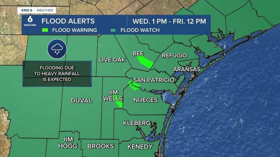
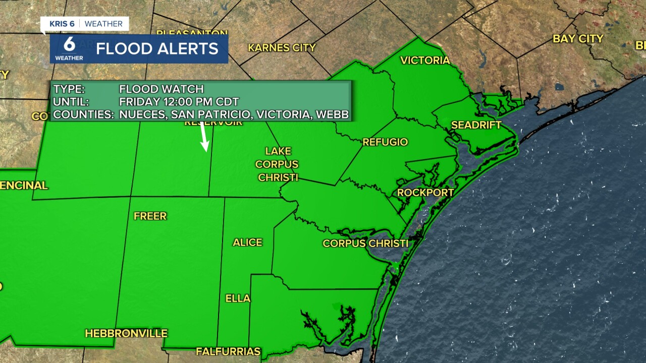
- A Flood Watch remains in effect through 12 p.m. Friday
- Flood Warnings is in effect through the weekend for Aransas River near Skidmore

Today's rainfall has gotten off to a late start, but the afternoon has quickly become soggy. Heavy rain is moving from the Rio Grande Valley to the Coastal Bend; the heaviest is trekking over coastal neighborhoods. This activity will continue through about 9 p.m. tonight. We'll get a break until about daybreak on Friday before a new line of storms moves in— this time from west to east. While one or two storms may get sporty tonight, the concern for severe thunderstorms is now focused on Friday.

_____________________________________
WEDNESDAY, MARCH 26
7 p.m. update -
- A Flood Watch remains in effect through 12 p.m. Friday
Flood Warnings are in effect through the weekend for the following:
- Aransas River near Skidmore
- Nueces River near Bluntzer and Tilden
San Fernando Creek near Alice
Significant rainfall is expected across the Coastal Bend. Rain we haven't had in a long time. In fact, here is a list of some of the biggest rainfall events in Corpus Christi since 2021:

Multiple batches of showers and thunderstorms will move across the Coastal Bend tonight, Thursday, and Friday. Don't be fooled by breaks in the rain, the confidence is high that this event will bring the highest rainfall accumulations we've seen in months. Most neighbors will see between 3-7 inches of rain, though it is expected that a few neighborhoods will see isolated higher rainfall totals.


Flooding, frequent lightning, and strong winds are all possible while storms roll through. The greatest threat for strong thunderstorms, while be on Thursday evening. Flooding will be a concern throughout the rain event. Please check stay up to date on the forecast as your KRIS 6 Weather Experts track the latest forecast.
2 p.m. update -

Rainfall arrives in our neighborhoods starting Wednesday afternoon. Heavier rainfall is anticipated overnight into early Thursday morning with the most accumulation expected. By Friday afternoon, showers move out of the Coastal Bend and taper off to the northeast.
Alice Neighborhood news reporter Melissa Trevino shared a video of the downpour in Alice -
Southside Reporter Tony Jaramillo sent us this video of beautiful, rain-filled gutters in Flour Bluff on Wednesday.
1:29 p.m. update -
Majority of our neighborhoods are now under a Flood Watch through Friday noon. Some of you have messaged me that it's already raining in your area and I just posted a time lapse of Doppler Radar showing us the past three hours to current conditions. The rain will pick up and intensify as we head into our later afternoon hours and overnight into Thursday morning.
With our given drought conditions, it is possible to see Flash Flood Warnings soon as heavy rainfall piles on top of dry soil/vegetation.
2:11 p.m. update -
12:53 p.m. update -

Rain chances are off the chart (literally) for the next couple of days. Rain starts to pick up this afternoon into our overnight hours heading into Thursday (heaviest rainfall).
The Flood Watch alert goes into effect at 1p today through Friday noon. A Flood Warning will go into effect Thursday morning through Friday afternoon for the following rivers: Nueces River, San Fernando Creek, and the Aransas River.
11:53 a.m. update -
As showers make their way to the Coastal Bend over the next few hours, our current dry conditions along with the anticipated rainfall amounts are prompting a Flood Watch that will go into effect at 1PM today through Friday at 12PM. Rainfall estimates range from 3-7 inches over the course of our rain event.
The Weather Prediction Center has the Coastal Bend under a moderate risk (level 3 of 4) for excessive rainfall, and tomorrow a slight to moderate risk (levels 2 to 3 of 4).
Stay weather aware and stay tuned to the forecast!
_____________________________________
TUESDAY, MARCH 25
1:10 p.m. update -

Starting Wednesday, March 26, showers will kick off during the day, heaviest rainfall on Thursday, wrapping up Friday. Flooding at this time is expected to be marginal and on the lighter end due to months of drought. We will still have warm temperatures throughout the week-- Thursday brings the most seasonal temperatures with highs in the mid 70s.
12:47 pm update -

A Flood Watch will be in effect from Wednesday to Friday ahead of this week's expected heavy rains.
_____________________________________